A Message from the President

Photo by Amy Mathews
When 2020 began, SkyTruth was preparing for the 10-year anniversary of the worst environmental disaster in U.S. history: the Deepwater Horizon oil spill in the Gulf of Mexico. SkyTruth had played a central role in revealing to the world the true scope of this disaster as it was unfolding, tracking the oil’s spread across the Gulf with satellite imagery. We demonstrated that the amount of oil spewing into the Gulf was more than 20 times greater than what BP and the U.S. Coast Guard initially claimed. And our findings drew national and international media attention, creating pressure on the federal government to measure the actual size of the spill more accurately. The government’s revised measurements ultimately formed the basis for the restoration and recovery fees that BP owed to the American people.
Our goal at the spill’s 10th anniversary was to remind policymakers and the public that such a disaster could happen again, that oil and gas extraction practices in U.S. waters had not improved sufficiently, and that the Gulf of Mexico remains particularly vulnerable to such disasters. To emphasize the importance of our message, we had scheduled a live news conference at the National Press Club in Washington, D.C., to attract major media outlets.
Then COVID-19 hit the nation hard.
Our team quickly pivoted to an online event, seamlessly coordinating presentations from four outside experts (plus me) to highlight the technical, geological, biological, and policy issues that keep us vulnerable to future disasters. Our event drew more than 35 journalists and others, and triggered news stories that appeared in more than 80 outlets. I’m proud of how our technical, communications, and management teams pulled together on such short notice to successfully raise public awareness.
But that was just the beginning of a remarkable year.
Our April event set the stage for continued successes throughout 2020 despite the global pandemic. When we temporarily shuttered our main office in Shepherdstown, West Virginia, in mid-March, virtually all staff and interns worked remotely for the rest of the year. But SkyTruth is a conservation technology organization: we are well-positioned to stay connected and productive by working remotely while communicating regularly.
The proof is in our accomplishments. Many of those accomplishments advance our Conservation Vision program; that is, our effort to apply machine learning to the growing quantities of satellite data available and automatically detect environmental changes on Earth. Those accomplishments include major progress detecting oil pollution at sea and drilling activities on land. They include expanding our mountaintop mining work to examine recovery of mined sites and identifying harmful algal blooms from space. And they include winning an international award that will allow us to reveal illegal mining in the Amazon rainforest — a biodiversity hotspot essential for protecting global climate. I hope you enjoy learning more about each of our projects below and, as always, please feel free to reach out if you have any questions.
2020 Highlights
- Advanced our machine learning model Cerulean to automate the detection of oily bilge slicks in the ocean — a first step to holding polluters accountable and stopping oil pollution at sea.
- Completed our project with researchers at Kent State University to detect harmful algal blooms from space, making their model more accessible to other researchers, easier to update and modify, and able to run on entire collections of satellite imagery, vastly expanding the model’s capabilities.
- Developed models to automate the detection of oil and gas drilling by applying machine learning to satellite imagery in remote, culturally and biologically important areas, such as Chaco Culture National Historical Park and the Patagonian steppes of Argentina.
- Expanded our monitoring of coal mining in Central Appalachia to begin examining the recovery and reclamation of these dangerous and degraded sites.
- Began our new Project Inambari to detect illegal and unregulated mining in the Amazon rainforest, to protect Indigenous communities and biodiversity.
- Updated our signature SkyTruth Alerts program to allow users to detect even more environmental impacts in new places, and to support projects Cerulean and Project Inambari.
I just finished a wonderful webinar by SkyTruth – Remote Sensing and the Environment in the Age of Big Data. Great information, amazing team!
Program Updates
Securing healthy waters and oceans
Stopping Oil Pollution at Sea with Cerulean: Our work monitoring bilge dumping in the world’s oceans took a big leap forward in 2020. This pollution occurs when cargo vessels and tankers illegally dump oily bilge water — the thick oily sludge that drains into the bottom of a vessel — into the ocean. International law specifies how bilge water should be treated to protect ocean ecosystems. But SkyTruth has shown that many ships bypass costly pollution prevention equipment by simply flushing the bilge water directly into the sea. And they routinely get away with it.
Previously, SkyTruth analysts examined satellite images manually to detect the telltale dark slicks trailing behind vessels. But with support from Amazon Web Services (AWS), we developed a machine learning model that automates our workflow for identifying bilge dumps from vessels. This means that we have essentially trained computer models to detect these slicks far faster than we could manually, enabling us to analyze thousands of satellite images every day. We call this effort Cerulean. And with the recent addition of Automatic Identification System (AIS) broadcasts to the processing pipeline, we’ll be able to identify the vessels potentially responsible for the slicks that our model detects.
Cerulean has been focused on identifying bilge dumps from moving vessels, but we’re working to detect leaks and spills from offshore oil platforms and vessel anchorages as well. Despite our progress, we’re still missing a lot of slicks. We rely on the European Space Agency’s Sentinel-1 radar satellite for Cerulean because it’s free and easy to access in AWS. But most of Sentinel-1’s coverage is along coastlines and near-shore areas, not the open ocean. Right now, we’re only seeing about 1.5% of the oceans every day. Even so, we found 164 oil slicks over Cerulean’s first 30 days of fully automated operation. As more and more satellites are launched, creating data for ever larger areas of the oceans, Cerulean will help us detect even more bilge dumping — everywhere it occurs.
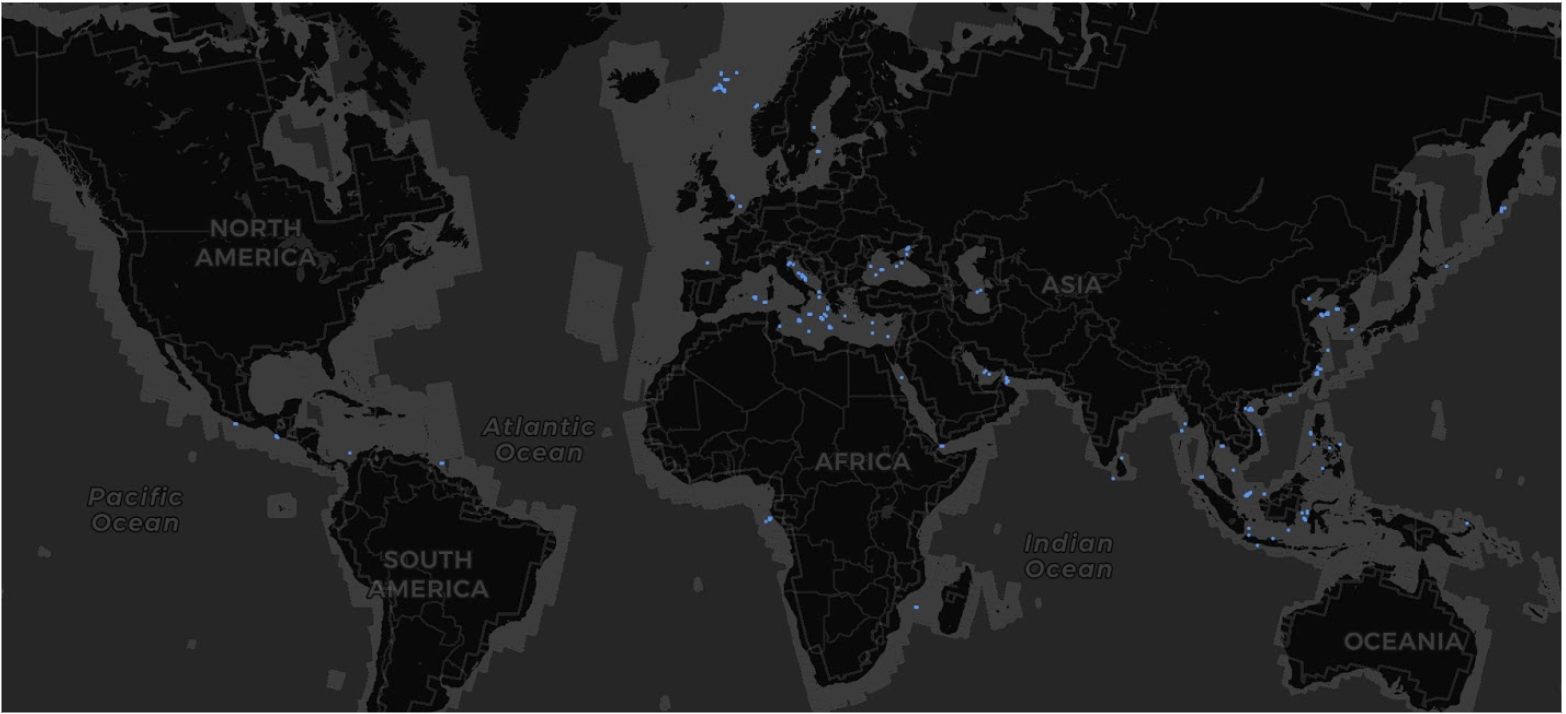
Oil slicks detected during Cerulean’s first 30 days of operation
To make that happen and stop this illegal, but apparently routine, pollution, we’re working with commercial imagery providers to gain access to more satellite radar imagery and cover larger swaths of open ocean. We’re also developing partnerships with coastal nations, enforcement agencies, prosecutors, and public campaigners to make sure that the intelligence produced by the Cerulean pipeline is used to stop polluters.
We also substantially ramped up our analyst-driven effort to monitor the ocean for bilge dumping by expanding our internship program to accommodate four interns. Each intern was assigned a “high-likelihood” section of the ocean to monitor each day using satellite radar imagery. In the cases where we can manually identify a likely culprit using AIS tracking, we post the images and analyses to our blog and social media accounts. But even when we can’t identify a likely culprit, we’re adding those new intern identifications to our set of training images that helps our machine learning model continue to learn and improve its predictions.
Detecting Harmful Algal Blooms: Throughout 2020, SkyTruth analysts collaborated with Professor Joseph Ortiz’s lab at Kent State University (KSU) to implement a novel water quality analysis that identifies harmful algal blooms (HABs) using satellite imagery in Google Earth Engine. HABs affect every coastal and Great Lakes state in the United States and are a burgeoning problem worldwide. Usually, algae are harmless, but under the right conditions, they can grow out of control, and some of these blooms can release toxins that kill wildlife and make people sick.
SkyTruth has been working with Dr. Ortiz to automate and scale his lab’s technique for detecting cyanobacteria (blue-green algae) in Lake Okeechobee in Florida and in the western basin of Lake Erie — both known hotspots for HABs. But waters like Lake Erie are complex: different types of algae, cyanobacteria, suspended sediment, and other aquatic material can make it difficult to pull the signal (the cyanobacteria that causes problems) out of the noise (all of the other stuff). The KSU method makes it possible to separate these different components.

Landsat 8 satellite image of Lake Erie spectrally filtered using KSU’s HAB detection method.
But the KSU spectral decomposition method wasn’t optimized to deploy in the cloud, meaning that each image had to be downloaded and analyzed locally on a desktop computer. We’ve implemented the KSU spectral decomposition method in Google Earth Engine, making the method more accessible to other researchers, easier to update and modify, and easier to scale-up to run on entire collections of satellite imagery, rather than just one image at a time. Combined, these improvements vastly increase the model’s capabilities.
We presented this work at Google’s 2020 Geo for Good event, and hosted a virtual meetup with more than 35 people attending, including key staff from the Earth Engine development and engineering team. You can read more about this project and view our virtual meetup from our blog post.
Restoring Clean Air and a Stable Climate
Mapping and Visualizing the Spread of Fracking: Fossil fuels drive climate change. SkyTruth has been monitoring hydraulic fracturing (“fracking”) for oil and gas since our founding almost 20 years ago, and researchers have used our work to document some of fracking’s environmental and health impacts, including from air pollution. These days, we’re applying machine learning techniques to automate the detection of oil and gas drilling sites on satellite imagery — speeding up the process and vastly increasing our capacity to detect changes on the ground. We’re testing this approach in two places: (1) northern New Mexico and the region immediately surrounding the Chaco Culture National Historical Park, and (2) the Patagonian and Andean steppe of Argentina, in partnership with the Wildlife Conservation Society (WCS).
Oil and gas drilling dots the archeologically rich landscape surrounding Chaco Culture National Historical Park in New Mexico, and is steadily closing in on the monument’s boundaries. Chaco Canyon is a UNESCO World Heritage Site, and it contains the ruins of a 1,200 year old city that is sacred to native people. The Patagonian steppe and its wildlife face a number of threats, but perhaps the most immediate is the construction of more than 25,000 miles of oil and gas exploration roads that have exposed previously inaccessible areas to poaching.
To make matters worse, public information about that vast network of roads, drilling sites, and pipelines in both of these geographies is incomplete and unreliable. And this makes it difficult for conservationists and activists to accurately assess the scale and intensity of the risk to sacred lands and threatened and endangered species. SkyTruth is using machine learning models to search through the satellite imagery archive available in Google Earth Engine to find drilling sites, roads, and pipelines missing from the existing data.
Our work in Argentina has focused on the Neuquén basin — one of the most important oil and gas producing areas in Argentina and a top priority for our partner, the Wildlife Conservation Society (WCS). One of WCS’s key goals in the region is to understand how the number and distribution of wells, roads, and pipelines has changed over the past decade in order to improve their conservation planning work with the Argentine government going forward. Our ongoing work will inform WCS’s conservation efforts in the region.
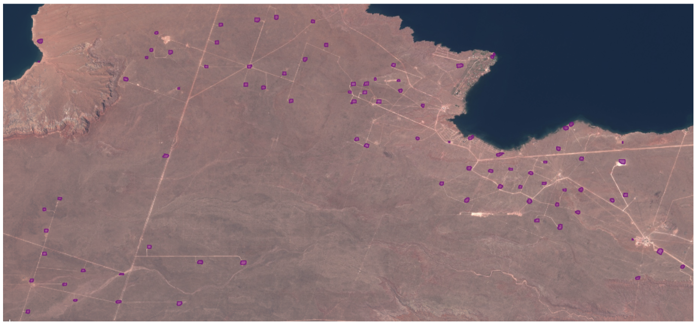
Fracking sites detected by our machine learning model in Patagonia
We authored an in-depth, three-part blog series that walks through the details of our machine learning workflow step-by-step. Our most recent model returned precision and recall metrics of 67% and 75%, respectively. This means that 67% of the locations we’re predicting as drilling sites actually are drilling sites, but we’re only picking up 75% of the drilling sites that are actually out there in the world. We’ve been adding more training data (to “teach” the model how to better identify drilling sites) and fine tuning the model, but we’re also in the process of adding another class — roads — to make the output even more useful for our conservation partners.
Safeguarding lands and communities
Measuring Recovery from Coal Mining: SkyTruth has been mapping the extent of surface coal mining, particularly mountaintop mining, in central Appalachia for more than five years, and this project has entered an exciting new phase. The landscape-scale disturbance caused by mountaintop mining creates serious barriers to the recovery of native Appalachian forests. Although mine operators are required to set aside bond money to restore the landscape to its original condition after mining operations are finished, these efforts are often inadequate — or mining companies go bankrupt — and the burden for additional reclamation falls on states and local communities.

Land disturbed per metric ton of coal produced in central Appalachia
This year, we joined forces with National Geographic and the conservation group Appalachian Voices to provide data for a web mapping application showing where reforestation on mined land was happening successfully and where it was not. We used deep time-stacks of satellite imagery to assess whether restoration is actually taking place. Once mining sites are no longer active, they are compared to reference forests located in the same ecoregion.
We used Google Earth Engine to aggregate spectral metrics for all central Appalachian mine sites from 1984 onward using Landsat imagery. We’ve created a “spectral fingerprint” for each mining area, and by comparing the spectral signatures of former mine sites to those of nearby healthy forests we can track and measure the effectiveness of different reforestation practices. Appalachian Voices is using our data to build a user-friendly app that provides the public (and regulators) a robust, visual tool to measure recovery, hold polluters accountable, and ensure better compliance with federal law.
Improving SkyTruth Alerts: Many skytruthers are familiar with our SkyTruth Alerts platform. It provides an easy way for anyone to subscribe to an Area of Interest (AOI), and then receive alerts whenever we find certain environmental incidents, such as a new drilling permit, a hazardous chemical spill, or a change in land cover, in those areas.
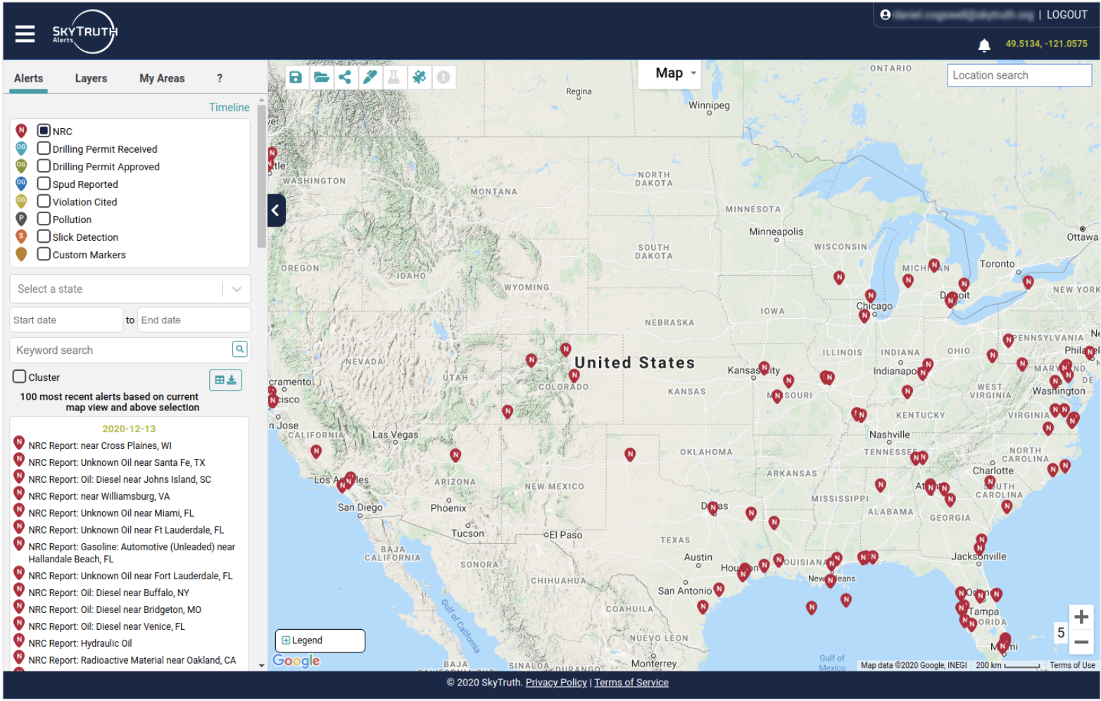
SkyTruth Alerts
In 2020 we added a feature to let users create their own channels, including any parameters of interest to them – such as the type of alerts they receive and areas of interest. Users can invite other people concerned about the same area and issues to join their channel, creating a community of concerned citizens. We brought more satellite imagery into Alerts, including high-resolution Planet images, allowing users to select and directly compare images from different dates (so they can identify places where changes have occurred in the landscape, from land clearing, logging, drilling, mining or other activity). We also made it possible for users to add notes, drawing, and other types of annotation to the images, and create and share their own custom maps based on their observations.
Protecting a legacy of biodiversity
Detecting Illegal Mining in the Amazon: We’re tremendously excited to have been chosen as one of the winners of Conservation X Labs’ Artisanal Mining Grand Challenge. Our effort, Project Inambari, uses a combination of radar and multispectral satellite imagery to identify and track unregulated and illegal mining deep in the Amazon rainforest. Small-scale mining for gold in the Amazon has grown precipitously in recent decades. Miners scour waterways and separate tiny flecks of gold from sediment with toxic mercury, devastating broad swaths of river and forest habitat. The mercury poisons fish, wildlife, and drinking water for thousands of Indigenous people downstream. Because it’s unregulated or illegal — and usually occurs in remote parts of the forest — there is little reliable data on the location of mining operations. And that lack of information makes it difficult for enforcement agencies and conservation groups to shut down operations at an early stage. Satellite remote sensing can help.
But satellite imagery faces a particular challenge in the Amazon: high cloud cover for significant portions of the year obscure activities on the ground from multispectral satellites such as Landsat 8 or Sentinel-2. So, we’ve used an approach that combines the cloud-piercing capabilities of Sentinel-1 radar imagery with multispectral information from Landsat 8 and Sentinel-2. We’ve also partnered with researchers at Wake Forest University and the Center for Amazonian Scientific Innovation (CINCIA) to incorporate their drone imagery of mining sites and their on-the-ground knowledge of mining activities into our approach.

Project Inambari: Annual detection of illegal mining in the Madre de Dios region of the Peruvian Amazon
By combining radar and multispectral imagery in Google Earth Engine, we’re able to generate monthly maps showing where mining is located, regardless of cloud cover. We’re making the data publicly available to activists, government agencies, and others through our Alerts platform (more on this below), and working to expand our analysis across the entire Amazon.
Supporting Project Inambari and Cerulean with SkyTruth Alerts: The new features that we added to SkyTruth Alerts made it the perfect platform for Project Inambari and Cerulean. We started using some new software libraries to power Alerts because of the size of some users’ data sets. This upgrade turned out to be very useful for our Project Inambari map. Our model outputs were very large datasets containing polygons delineating suspected mining activity. In some years, the outputs contained close to 90,000 polygons — quite a bit more than the original Alerts platform could have efficiently handled. But, after we switched over to using the same mapping technology that our colleagues at Global Fishing Watch are using to process and render very large datasets, Alerts was able to process and display big data sets without a problem.
Another upgrade to Alerts helped make our Cerulean map possible. Until now, an ‘alert’ had to be identified as a single point on the map. But the machine learning processing pipeline we built for Cerulean produces the outline of a slick — a polygon, not a point. By making it possible for any shape to be an ‘alert,’ we’ve paved the way for future Conservation Vision projects to use the Alerts platform. This upgrade allows us to add important data streams to the Alerts platform in the future, such as proposed oil and gas lease parcels, mining permit boundaries, and other regions of concern, that we haven’t been able to leverage until now.
Very professional and information-rich job on the [Deepwater Horizon] webcast! Thanks for your work on this.
SkyTruth 2020 Board of Directors
 Alan Septoff – ChairStrategic Communications Director, Earthworks
 Susan Kemnitzer – TreasurerRetired Deputy Division Director, Division Of Chemical, Bioengineering, Environmental, and Transport Systems, National Science Foundation
 Catherine Irwin – SecretaryRetired Managing Director, Contemporary American Theater Festival
Former Campaign Manager, Shepherd University
 Walter AilesRetired Educator and Former Assistant Head, Georgetown Day School
Former Assistant Head of the Edmund Burke School
 John AmosPresident, SkyTruth
 Mary Anne HittNational Director of Campaigns, Sierra Club
 Darshan KarwatAssistant Professor, School for the Future of Innovation in Society | The Polytechnic School at Arizona State University and Founder, re-Engineered
 Monica MedinaIndependent Consultant and Editor, Our Daily Planet
Adjunct Professor in the School of Foreign Service at Georgetown University
 Barbara MorganDistinguished Educator in Residence, Emeritus, Boise State University,
NASA Astronaut (retired)
 Stephen J. ParadisMember, Town Council of Bolivar, WV, and President, Bolivar Planning Commission
Former Chief Operating Officer, Appalachian Trail Conservancy
 David Shearer – Board Science AmbassadorChief Executive Officer, Co-founder, Full Circle Biochar
 Hank WillardPresident, Agronomy Air
 Paul WoodsChief Innovation Officer, Global Fishing Watch
Your alerts make a huge difference on my ability to protect the Basin.
Financials


