NASA Earth Observatory image modified by SkyTruth

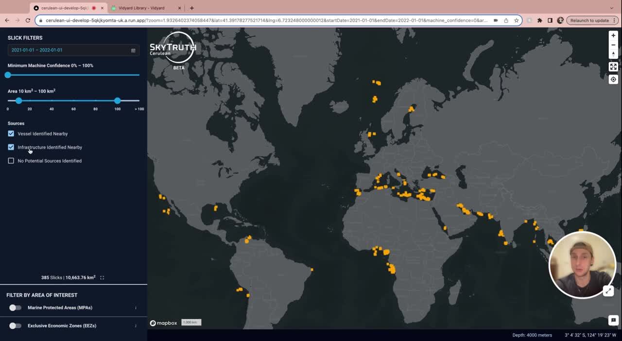
Cerulean is SkyTruth’s global monitoring system for ocean oil pollution, designed to detect oil slicks in satellite imagery and identify nearby vessels and offshore oil infrastructure that could be the source of those slicks. Our free map application is designed to enable anyone with an internet connection to find and fight oil pollution across the ocean. For API data access, see our API docs.
What is Cerulean?
SkyTruth is proud to introduce Cerulean — a tool used to monitor for human-caused oil slicks occurring in oceans and seas around the world. Cerulean uses machine learning to identify oil slicks in radar satellite imagery, then analyzes the locations of marine vessels and offshore oil platforms to identify each slick’s potential source. But no model is perfect. Our model results point you toward possible slicks and sources, which then require manual verification in our map interface. We provide some simple guides to help you with that verification.
Cerulean is intended to support climate and marine conservation organizations, journalists, enforcement agencies, and any individuals or agencies that strive to protect their waters from oil pollution. Users can monitor selected areas for oil and generate reports showing possible culprits including nearby vessels or infrastructure. Cerulean allows users to investigate individual incidents while also providing a broader picture of chronic oil pollution issues globally.
Cerulean will continue to grow and develop through user feedback and added functionality. Please try out the Cerulean application, let us know how we can improve the experience for you, and help us eliminate marine oil pollution and expose the costs of offshore oil development around the world.
Why is Cerulean necessary?
Cerulean is designed to detect both acute and chronic oil pollution from vessels and offshore oil platforms. These two sources of oil pollution have created a growing problem in our oceans. Shipping vessels transport 80% of global trade by volume, and the vast majority use heavy fuel oil (HFO), one of the world’s dirtiest fossil fuels. The initial six-month pilot of Cerulean revealed a startling portrait: ships may be dumping more than 1.8 million barrels of oil per year into the ocean.
Meanwhile, offshore oil production is rapidly expanding to extract the world’s untapped reserves that lie beneath the ocean floor. The expected growth of shipping and oil development increases the likelihood of undetected pollution, resulting in devastating impacts to marine ecosystems, and to the health and ocean-dependent economies of coastal communities.


How does Cerulean Work?
This is an introduction to the methods and models that power Cerulean, from data collection, to oil slick detection, to identifying the potential sources of chronic oil pollution. For a more detailed methods description, please see our methods page.


Early Findings


Cerulean in Action
Fighting Offshore Drilling in Latin America and the Caribbean
The Interamerican Association for Environmental Defense uses the law and science to protect communities suffering from environmental harm. They plan to use Cerulean to expand their work against offshore drilling, which is growing in the area despite serious risks to ocean biodiversity and the livelihoods of coastal communities.
Read More
Empowering Ocean Advocates
Andrew Dixon epitomizes the independent Cerulean user – a diligent watchdog for the waters surrounding Nikoi Island, his 37-acre resort off the east coast of Bintan, Indonesia. Since anyone with an internet connection can use Cerulean to track oil spills and its potential culprits, that is exactly what Dixon is doing.
Read More
Increasing Maritime Security in Indonesia
The Indonesia Ocean Justice Initiative works toward policies that promote ocean protection, sustainable use, and equitable welfare. They are using Cerulean to alert government officials when oil spills occur, and empower those whose livelihoods depend on the sea with scientific data about what’s happening in their communities.
Read more
Investigating the Overlooked Culture of Illegal Bilge Dumping in Europe’s Seas
SkyTruth collaborated with a team of journalists and media outlets led by investigative newsroom Lighthouse Reports to inspect the problem of chronic (and often illegal) oil pollution by vessels transiting European waters. SkyTruth’s investigation revealed the actual number of pollution events to be much higher than the officially reported statistics.
Read more
Exposing Biodiversity Loss in UK Waters
The climate advocacy organization, Uplift, alongside ocean advocacy group, Oceana, used Cerulean data to reveal how oil and chemicals released into UK waters by the oil and gas industry harm endangered whales, dolphins, seabirds, seals, and cold water reefs. They published a report revealing that these species are subject to a constant flow of small spills.
Read more
The Future
In 2024, we aim to develop Cerulean into an indispensable tool for stopping ocean oil pollution and revealing the hidden consequences of offshore oil and gas production. To do that, we’re planning some important work for the coming year.


Tutorials & FAQ
Getting started
Identifying vessel sources
Identifying Infrastructure sources
Questions about Cerulean
What kinds of pollution does Cerulean detect?
Cerulean automates satellite-based detections of marine oil pollution incidents and the identification of their likely sources, primarily shipping vessels and offshore oil and gas platforms. Oil slick detections by Cerulean enable investigations of potential bilge dumping incidents and chronic pollution from offshore oil and gas operations.
How does Cerulean’s automation work?
Cerulean uses machine learning and cloud computing to scan all European Space Agency Sentinel-1 satellite data collected over the ocean and inland seas to detect potential oil slicks. There are a few steps to this process:
- Whenever new Sentinel-1 imagery becomes available over the ocean, the scene is automatically scanned by our computer vision model, which is trained specifically to detect oil slicks in Sentinel-1 data.
- If oil slicks are detected, another set of models tries to identify the potential source. These models use ship locations, from automatic identification system (AIS) data, and offshore oil platform locations to find the potential sources that most closely match the location and timing of the oil slick.
- Slick and source information are added to a database, which is then made available in our map-based user interface.
For detailed information, please review our methodology.
How can I access Cerulean?
Cerulean data is accessible via a publicly available web application providing oil slick detections, potential source information, and satellite imagery. The technology is free to all, giving users easy access to imagery and data needed for investigations, research, and analysis. Cerulean’s ease of use and openness embody our values of transparency and scientific integrity. For API data access, see our API docs.
What do you do once you find a slick to help address the problem?
SkyTruth makes all oil slick detections publicly accessible on the Cerulean platform and API. We provide capacity building support for investigative journalists, enforcement agencies, advocates, researchers, and other users to interpret pollution trends and incorporate Cerulean into their work. SkyTruth does not determine the intentionality or illegality of any oil slick detected by Cerulean, and SkyTruth does not provide direct response services to ongoing oil spills. If you think Cerulean can help your work, get in touch with us at support@skytruth.org.
What is the geographic coverage of Cerulean?
Cerulean’s geographic coverage focuses on Exclusive Economic Zones of coastal countries due its dependence on free radar satellite imagery from the European Space Agency’s Sentinel-1 mission. Sentinel-1 provides coverage up to a few hundred to a couple thousand kilometers offshore, covering 47% of global shipping lanes and 85% of offshore oil and gas extraction activity. The map below displays the area and frequency of coverage in 2022. Sentinel-1 radar imagery is unaffected by atmospheric conditions, enabling it to make detections even in cloudy weather.
Cerulean does not currently monitor most of the open ocean. We are exploring options to fill in these gaps, including commercial satellite data and non-radar multispectral imagery. Earth-observation systems planned for launch over the next 3-5 years will greatly improve the extent and frequency of our coverage in the ocean. A new upcoming Sentinel-1 satellite (replacing an older spacecraft that was decommissioned in 2021) will double our monitoring frequency, and other public radar satellites are scheduled to enter service in the next several years.

What’s the time gap between satellite image collection and publication of Cerulean detections?
When the Sentinel-1 satellite passes any given area, its imagery typically becomes available to the Cerulean model within 6-12 hours. In a matter of minutes, Cerulean automatically scans new imagery and generates new results.
Cerulean’s AIS data source, which enables the attribution of oil slicks to potential vessel sources, operates with a 72-hour delay. Therefore, live attribution of oil slicks to potential vessel sources is not currently available.
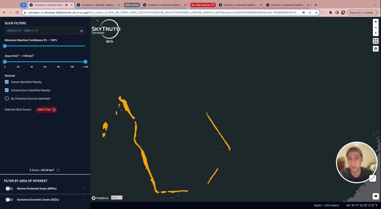
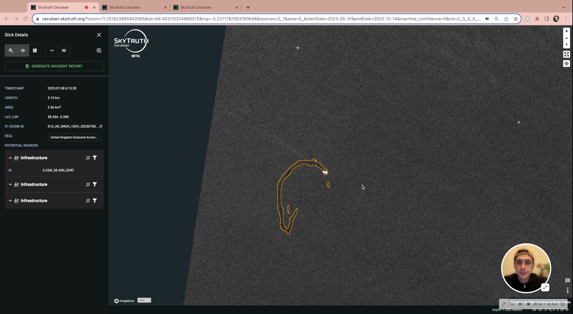
How do you rate your confidence in a particular slick detection?
Cerulean is designed to accurately outline the shape of oil slicks against seawater. A high confidence score of a slick detection indicates that the highlighted patch of sea surface displays characteristics consistent with hundreds of confirmed oil slicks on which we have trained the model.
Attributions of slicks to a potential vessel source or piece of fossil fuel infrastructure are more complex. We consider numerous factors, including an analysis of which vessels, platforms, or other infrastructure were in the area when we detected a slick; how closely a moving vessel(s) passed through the slick area; and how closely the movement of the slick’s centerline matches those vessel trajectories. From this data, Cerulean will generate several possible associations between oil slicks and their potential sources. For each associated vessel or infrastructure site, Cerulean provides a confidence score indicating the likelihood of each association. Cerulean’s attributions are only as good as the AIS data supplied to the model; there is a possibility that the actual polluter is a so-called “dark” vessel that was not broadcasting an AIS signal.
How accurate are your slick detections?
It is not possible to definitively identify oil slicks using synthetic aperture radar (SAR) satellite data alone. All Cerulean detected oil slicks should be considered potential oil slicks, not definitive oil slicks. We are still finalizing our slick detection model, so false positives should be expected. Final model accuracy is to be determined.
One important feature of our user interface is the ability for users to filter what they see on the map. For instance, if someone only wants to see slick detections that have a very high level of confidence, we allow users to set that parameter and restrict the visible slicks. If someone wants to see every possible slick, even the ones with a lower probability of being true, users can adjust the display to show all detections.
Radar is a useful means of detecting oil slicks, but it does have limitations. Oil slicks appear as dark patches in radar imagery, but other phenomena can cause similar dark patches, including calm water in low wind conditions, sea ice, and wind shadows around islands and other objects at sea. Cerulean often detects these lookalikes as potential oil slicks. Cerulean is also limited in distinguishing oil slick type: Cerulean is not able to distinguish between mineral oil and vegetable, for example. Because of these uncertainties, Cerulean cannot determine whether an oil slick represents an illegal action, and we recommend that users independently verify all Cerulean’s detections before pursuing legal or other action.
How accurately can you identify sources using Cerulean?
It is not possible to definitively link a potential oil slick to a vessel or stationary source based on satellite imagery, ship location information (AIS), and offshore infrastructure locations alone. All potential oil slick sources identified by Cerulean should be considered potential sources, not definitive sources. Our models narrow the list of potential sources by finding the nearest AIS tracks or stationary sources (such as oil platforms) and providing those to users as a list of candidates. Users can then visualize those AIS tracks or stationary sources on the map and determine which, if any, are the most likely source. In some cases, it is not possible to make a clear determination, either because a ship isn’t broadcasting AIS at all, or because there are too many vessels close together that the source could be any of them.
Can you measure volume from slick detections?
We can’t measure volume, but we can estimate it using the area covered by each slick. Based on available research, we estimate that oil slicks visible in Sentinel-1 imagery are on average at least 1 micrometer thick, which is about seventy times thinner than a human hair. For every square kilometer of oil we see on the surface, we estimate that represents at least one cubic meter of oil.
For detailed information, please review this oil slick volume methodology here.
How is your work different from other oil pollution monitoring providers?
Cerulean is the first free and publicly available marine oil pollution monitoring tool, and its primary purpose is to reveal the hidden consequences of global shipping and offshore oil and gas development and to facilitate public action and accountability.