
Persistence on the Path to Becoming a Master Coder
Intern Austin Clack’s environmental monitoring projects reveal to him the enormous power traditional remote sensing techniques hold when paired with machine learning.
My name is Austin Clack. I am a SkyTruth intern and a UCLA Bruin, graduating this month. Since September of 2021, the exposure I’ve had to the wide range of SkyTruth programs and key issue areas has opened my eyes to the limitless potential remote sensing holds to provide invaluable insight into virtually any natural or anthropogenic phenomenon. I entered college as an environmental studies major, with a keen sense of environmental stewardship and a love for the outdoors. Still, I was unsure how these personal passions would translate into a career path. As an Audubon volunteer in high school, I had spent hours up to my armpits in mud, taking ecosystem health samples throughout the Bay Area’s estuaries. The Cosco Busan oil spill had covered the marine environment in a thick film of crude oil over a decade in the past but a black stain remained on the shoreline as a reminder of devastation that had taken place. While I enjoyed my work, I knew from that point forward that I wanted to engage in work aimed at identifying and averting environmental catastrophe before it occurred.
Following my first year of college, I discovered geographic information systems (GIS) as the mechanism for me to realize this aspiration. What better than a visual tool to promote the public’s grasp of the less tangible aspects of coastal inundation, deforestation, air quality inequity, or any complex and nuanced environmental issue? To visualize and interact with the very problems that are the topics of many political and social debates is to get closer to understanding their causes and potential solutions. My time spent at SkyTruth has, in many ways, represented the culmination of my academic pursuits and personal passions to use geospatial analysis techniques as tools to promote public interest and concern about environmental topics.
Less than a month into my SkyTruth internship, our work made its way to my Southern California community. On the morning of October 1st, an oil spill was detected off of the coast of Huntington Beach, a popular spot I’ve visited on occasion. The following Monday, the spill was discussed in my environmental justice class and my professor showed an interview featuring our very own CEO, John Amos, discussing the potential source of the spill and the likely fallout! The incredible breadth of our work had never been more evident to me than in that moment. As an intern, I was able to take part in spill detection work as well. One of the projects I contributed to on an ongoing basis was the monitoring and reporting of deliberate and illegal dumping of oil by cargo and container vessels, known as bilge dumps. I was responsible for monitoring the Southeast Asian ocean area, often trafficked by “dark” vessels that do not identify themselves or transmit their real-time locations in order to escape maritime authorities and sail under the radar. Over the course of my internship, I identified over sixty of these pollution events, the vast majority of which took place in the Java Sea, which lies between the Indonesian islands of Borneo to the north, Java to the south, Sumatra to the west, and Sulawesi to the east. Take a look at Sentinel-1 radar imagery on any given day and you are met by the sheer extent of the unanswered abuse to this marine environment.
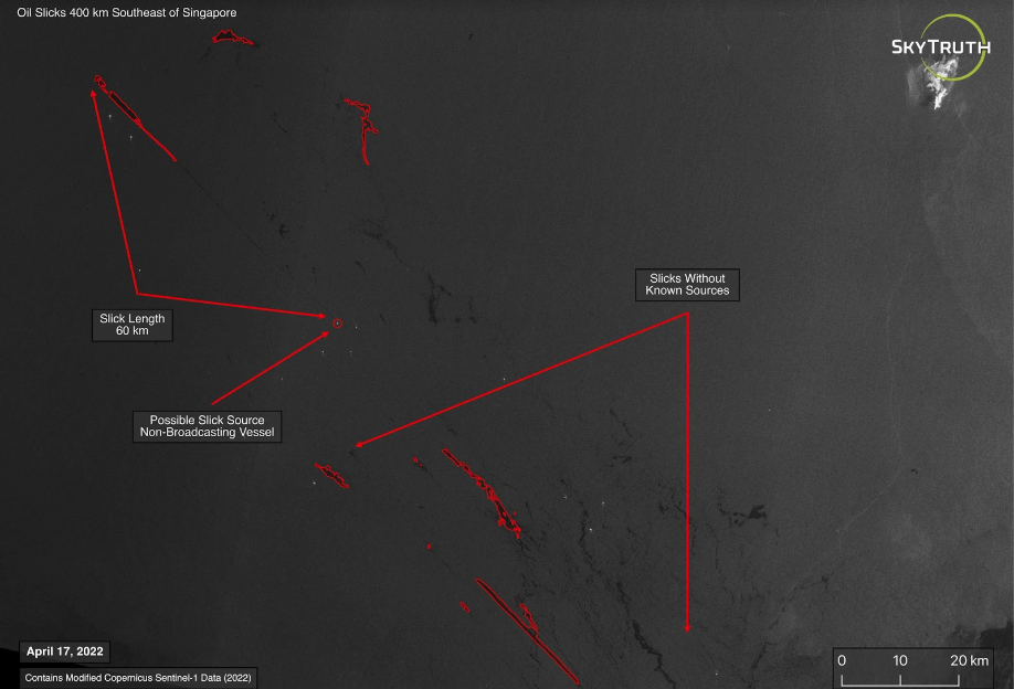
Scattered oil slicks, likely left behind by “dark” vessels that obscure their location and identity.

AIS vessel tracking data holds the potential to reveal bad actors that otherwise go unnoticed in the open ocean.
Oil presents in radar imagery as easily recognizable black scars that can stretch for kilometers across the surface of the water. By identifying bilge dumps, I was actively participating in the advancement of Cerulean, a machine learning model that harnesses the power of artificial intelligence to autonomously classify oil spills. I was blown away by the seemingly unlimited potential this technology held and met with its designer and implementer, the amazing Jona Raphel, to learn more and inquire how I might become more involved. Our conversation kickstarted the focus of my SkyTruth internship, mapping the pollution of the Venezuelan tidal bay Lake Maracaibo.
Lake Maracaibo lies in the northwestern corner of Venezuela within a basin fixed between two mountain ranges, the Méridas Andes to the southeast and the Sierra de Perija to the west. The topographic features of the surrounding area function to funnel rain water directly into the lake via a complex stream network that diverts runoff from upwards of sixty miles away. The result is a constant flow of water into the lake that pulls with it all of the natural and anthropogenic nutrients it has collected along its route. This overloading of nutrients catalyzes algae microorganisms like phytoplankton and duckweed to explode into major bloom events that can be viewed from space. Once algae dies, the process of its decomposition consumes dissolved oxygen, causing water hypoxia and rendering large expanses of aquatic environment dead. After discussing my interest in Lake Maracaibo with Jona, we explored possible overlap with Cerulean. The surface of Maracaibo is characterized by a swirl of black and green, as algal blooms mix with oil spills seeping from dilapidated extraction infrastructure. The patterns by which algal blooms and oil spills present in satellite images are very similar, making classification a challenge within Cerulean. Jona and I discussed how I might work on a methodology to extract one from the other, enabling Cerulean to make precise and reliable classifications when both algae and oil are present.
With the help of our incredible intern coordinator, Brendan Jarrell, I began to construct a workable code within the Google Earth Engine API. This was a huge hurdle for me: I began my internship with little to no experience writing code and quickly learned I would have to begin building my fluency. Our calls would consist of me telling Brendan the functions I wanted to perform and him walking me through how to write something that would accomplish this. Every week, I set aside time to watch Google Earth Engine tutorials and read through countless online forum discussions. There was an incredible amount of back and forth throughout this process and I am so appreciative of his patience and constant willingness to teach. The final product was an NDVI function that could be applied to a specific region of Lake Maracaibo on any given day and symbolized to pull out the extents of surface algal blooms while omitting other materials that might be recognized by the index. In doing so, the background noise of the lake was muted, highlighting the massive extent of algae present in the lake at all times. I was blown away by the ceaseless bloom that shrouded the lake year-round. While I am by no means a master coder, I feel as though I am leaving SkyTruth with the programming knowledge to produce valuable remote sensing analysis tools.

Algal blooms on the surface of Lake Maracaibo detected using NDVI analysis techniques within the Google Earth Engine API (09/22/2020).
The community I joined at SkyTruth has surprised and inspired me in ways I never could have anticipated. In my time at SkyTruth I have learned that regardless of the groundbreaking nature of your work or how passionate you are about your projects, your ability to communicate something complex to a non-technical audience is chiefly important. I have never been a part of such an eclectic group whose diverse range of skills and backgrounds mosaic in such a way that any issue confronted has the full force of SkyTruth behind it. I cannot recommend this internship enough and I am confident that I am more inspired, adaptively prepared, and fully confident I will continue to advance the SkyTruth mission as I continue on in my professional and personal endeavors.

