Systematic GPS Manipulation Occuring at Chinese Oil Terminals and Government Installations
Analysis reveals precise location and timing of GPS interference but purpose remains unclear.
Last month, an article in MIT Technology Review described strange GPS anomalies in Shanghai. I began investigating, and have now found evidence of a novel form of GPS manipulation occuring at at least 20 sites on the Chinese coast during the past year. The majority of these sites are oil terminals, but government installations in Shanghai and Qingdao also show the same striking pattern of interference in GPS positioning. We don’t know the reason for this interference. It may simply be a general security or anti-surveillance system but it is also possible that it is intended to avoid scrutiny of imports of Iranian crude which have recently come under U.S. sanctions. Whatever the intention, we are able to demonstrate here, through analysis of vessel tracking data, that this GPS interference can be pinpointed very precisely in both time and location.
According to the MIT Technology Review article, this phenomenon was first documented by the U.S. flagged container ship Manukai when the vessel entered the port of Shanghai in July. The captain noticed that the vessel’s AIS (Automatic Identification System) appeared to malfunction — vessels on the navigation screen appeared and disappeared without explanation and appeared to move when they were in fact stationary. AIS, originally designed for collision avoidance, transmits vessels’ GPS locations, courses, and speed every few seconds via VHF (very high frequency) radio. These signals are not only picked up by nearby vessels and terrestrial antennas, but some private companies have also launched satellites able to receive these signals. For this analysis we were able to use data made available by two of these companies, Spire and Orbcomm, through our research partnership with Global Fishing Watch.
An investigation by non-profit C4ADS (Center for Advanced Defence Studies) showed that AIS vessel locations from hundreds of ships navigating Shanghai’s Huangpu river were coming up at false locations. Strangely, vessels on the river would have their GPS location jump to a ring of positions appearing on land. And this was not just affecting ships; looking at the cycling and running app STRAVA’s tracking map of cyclists, C4ADS also confirmed that this strange pattern of interference was affecting all GPS receivers.
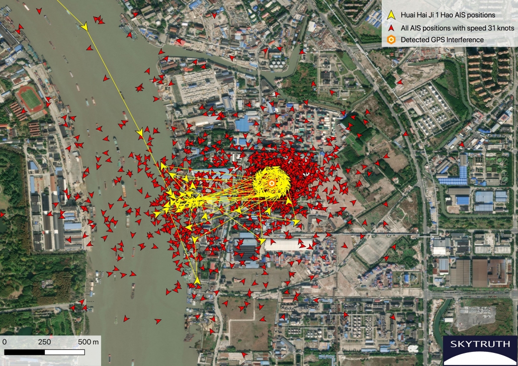
To further investigate the GPS manipulation documented in Shanghai, I examined AIS position broadcasts from ships in the area. A distinct pattern emerged. Upon approaching the area of interference, a vessel’s broadcast position jumps from the vessel’s true location to a point on land where false AIS broadcasts occur in a ring approximately 200 meters in diameter. Many of the positions within the ring had speeds of precisely 31 knots or 21 knots (much faster than vessels would be moving near dock) and showed a course varying depending on the position within the ring. The GPS anomaly appears to affect vessels once they are a few kilometers out from the center of the ring. Once affected, vessels begin broadcasting seemingly random positions within the ring or from other high speed positions scattered around it.

Image 1. The Chinese cargo ship Huai Hia Ji 1 Hao (yellow) transits southeast on the Huangpu river. Upon nearing the center of GPS interference area the track jumps to the ring on land and to other random positions nearby. Positions from other affected vessels are shown in red. AIS data courtesy Global Fishing Watch / Orbcomm / Spire.

Image 2. GPS interference can be pinpointed based on this ring of false AIS positions. Approximately 200 meters in diameter, many of the positions in the ring had reported speeds near 31 knots (much faster than a normal vessel speed) and a course going counterclockwise around the circle. AIS data courtesy Global Fishing Watch / Orbcomm / Spire.
Because the ring of false AIS broadcasts follows this very specific pattern, I was able to query AIS tracking data to check if there are other locations where these rings are also occurring. The results are striking. This GPS manipulation is occuring not only in Shanghai but has occurred in at least 20 locations in six Chinese cities within the past year. The focus of these apparent GPS manipulation devices is clearly oil terminals (where 16 of the 20 detected locations were observed). But three prominent office buildings in Shanghai and Qingdao are also affected: the Industrial and Commercial Bank of China in Shanghai, the Qingdao tax administration office, and the Qingdao headquarters of the Qingjian industrial group.

Image 3. A ring of false AIS positions marks an apparent GPS interference device deployed in an office building identified as the Qingdao tax administration office. AIS data courtesy Global Fishing Watch / Orbcomm / Spire.

Image 4. Locations of detected GPS manipulation occuring in six Chinese cities in 2019. Interference following this pattern was not found beyond the Chinese coast.
It seems likely that the centers of these rings of false AIS positions actually mark the physical location of some sort of GPS disrupting device. A device having precisely this effect on GPS receivers, including shipborne AIS systems, has not been previously documented, though there have been other cases of GPS blocking and manipulation. Earlier this year C4ADS published a report with details on GPS manipulation clearly being carried out by the Russian government. These Russian systems appeared to have the effect of making all receiving devices within range show some particular location, such as a nearby airport, rather than the true location of the device. This was seen in one striking example of vessels approaching Putin’s alleged palace on the Black Sea coast.
This Chinese system is clearly being deployed both at central government offices and at the much more remote locations of oil terminals. In the case of the government office buildings it seems likely that these GPS disrupting devices were activated as a security measure. Some are only active for a few days, perhaps to coincide with the visit of an important official. However, the AIS manipulation occuring at oil terminals particularly interests us at SkyTruth: One possible motive for deploying GPS manipulation devices at oil terminals could be recent U.S. sanctions on Chinese companies importing Iranian crude. And the intentional disruption of a navigation safety system, in close proximity to crude oil storage, is a serious concern.
Almost half of the specific locations where these presumed GPS disrupting devices have been deployed are at oil terminals near Dalian in northeast China. In an August analysis, The New York Times matched Planet satellite imagery from June and July with AIS tracking data to show Iranian tankers delivering oil to China in violation of U.S. sanctions. The Financial Times also documented Chinese flagged tankers importing Iranian crude after ship to ship transfers with Iranian tankers.
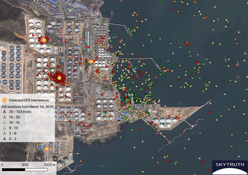
I took a closer look at exactly how this GPS disruption is affecting vessel tracking in one oil terminal east of Dalian. Here I identified four locations where GPS disrupting devices appear to have been deployed in 2019. I compared AIS vessel position data from March 1, 2019 and September 5, 2019. The differences were dramatic.
These two days showed similar numbers of AIS positions in the area. But on September 5 approximately two-thirds of the vessel positions at dock disappeared and appeared to be replaced by positions orbiting the GPS disrupting devices or scattered randomly in the region. At the same time, it does appear that some normal AIS broadcasts are coming through and that the GPS disruption does not entirely mask all vessel movements in the area.

Image 5. On March 1, 2019 AIS vessel position data around an oil terminal east of Dalian China shows accurate vessel positions and speeds. On that date, none of the four locations of GPS interference were active. Consequently no vessel positions appear on land and stationary vessels are accurately shown with near 0 speeds (green). AIS data courtesy Global Fishing Watch / Orbcomm / Spire.

Image 6. On September 5, 2019 two GPS interference locations were active and this had a dramatic effect on scrambling vessel positions in the area. Many positions now appear orbiting the presumed GPS interference devices and others appear scattered on land. On the water many positions are appearing with very high speeds (over 25 knots, red) and it’s not possible to distinguish true and false locations. However some slow speed positions (green) are appearing at dock where they would be expected, so some AIS broadcasts appear to be unaffected. AIS data courtesy Global Fishing Watch / Orbcomm / Spire.

Image 7. The distribution of AIS speeds in the area is significantly altered by the activation of the GPS interference devices. Above AIS speed distributions are compared between March 1 (left, no GPS interference) and September 5 (right, active GPS interference). On Sept 5 the total number of slow speed positions from docked vessels is greatly reduced and spikes now appear at 21 and 31 knots from positions orbiting the presumed GPS interference devices.
I also examined one individual vessel track to see how it was affected by GPS interference. This is the Chinese flagged tanker Jin Nui Zou which entered the Dalian oil terminal on September 5. Initially a normal track is seen as the vessel approaches the terminal from the southeast. With closer proximity to the presumed interference device, scrambled positions — often with very high speeds — start to appear. Eventually almost all of the vessel’s AIS positions appear in the ring orbiting the interference device.

Image 8. The tanker Jin Niu Zuo approaches an oil terminal east of Dalian on September 5. Initially, positions with normal transit speeds appear (yellow). With closer proximity, scattered high speed positions begin to emerge (red) and eventually most positions appear in the ring surrounding the presumed AIS interference device. AIS data courtesy Global Fishing Watch / Orbcomm / Spire.
The timing of GPS interference at different sites on the Chinese coast can be inferred based on the appearance of AIS positions on land with 21 and 31 knot speeds. Of the 20 locations identified, interference appears earliest at office buildings in Qingdao but only over a couple days (April 17 – 18, 2019). The first GPS interference at oil terminals appears in June and has continued until recently but timing varies by location. Activation of interference at different terminals is intermittent and may be in response to specific events. For instance at an oil terminal near Quanzhou GPS interference appears to have been activated only between September 25th and 27th, 2019.
At the Dalian oil terminals GPS interference appears to have begun in late June 2019. It is possible that this was a reaction to increased scrutiny of crude imports after the U.S. ended exemptions for purchase of Iranian oil on May 2nd. In fact, Dalian is the headquarters of two subsidiaries of Cosco shipping which were sanctioned on September 25 for importing Iranian crude. Based on what can be seen with vessel activity in Dalian, it is clear that GPS interference is not able to entirely mask vessels approaching the terminal. However, it likely would make it impossible to reliably link a vessel’s AIS track with satellite imagery of a vessel discharging crude at dock. While it is not at all clear that GPS interference was intended to obscure shipping activity, we do see that it had a significant impact on AIS tracking and that the interference was specifically concentrated at oil terminals.
In the November article first documenting the strange GPS anomaly in Shanghai, the question was posed whether this was the work of the Chinese state or some other actor like a mafia engaged in smuggling river sand. Based on the very specific characteristics of the GPS manipulation observed and its deployment at high level installations, it seems very likely that the Chinese state is responsible. It remains to be seen whether this is simply a security measure or if GPS manipulation is also being deployed specifically to prevent monitoring of oil imports.


