Update on Our Efforts to Map Surface Mining in Appalachia
[The Mountain Top Removal visualization tool has been retired, but the MTR data is updated annually.]
Some time has passed since we’ve written about our work mapping surface mining in central Appalachia, but rest assured, we’re still actively monitoring this devastating practice. Our mining work to date has focused on mapping the locations of these operations.
Researchers, some of whom are using our data, are beginning to draw troubling connections between coal mining and the health of people living in communities near those operations. We are working to refine our mapping processes and enable new types of analysis to help understand the environmental and public health consequences of mountaintop removal mining.
The process we used to create our annual maps of surface mining from 1985-2015, relies on the use of a Normalized Difference Vegetation Index (NDVI). NDVI essentially measures a ratio of reflected red and near-infrared light and is particularly useful for detecting changes in vegetation. When areas within the scope of our study experience a change from forest to bare earth, this registers as mineland. The analysis is available here: skytruthmtr.appspot.com

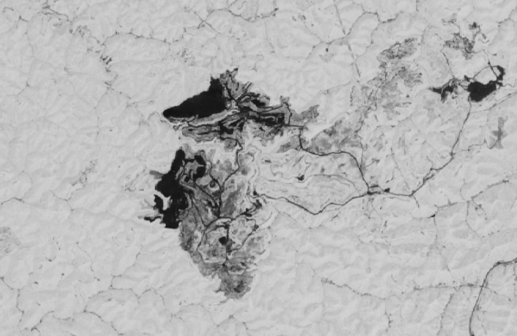
This NDVI image shows the Hobet 21 Coal Mine in West Virginia. Vegetated areas are visualized in white, while bare earth is seen as dark grey or black.
We are working with Dr. Matt Ross, an ecosystem scientist from the University of North Carolina at Chapel Hill, to improve our mining identification algorithm, and add the capacity to evaluate how landscapes affected by surface mining recover over time. This algorithm is an integral step in assessing the efficacy of the reclamation efforts undertaken by mine operators. We expect our mapping will allow researchers to conduct more robust studies on the long-term environmental and health impacts of surface mining, which in turn will help mining-impacted communities hold industry and government accountable for repairing the damage done to Appalachian landscapes, ecosystems and public health. We also hope the work will stimulate government investment as coal mining declines throughout the region, enabling a just transition to a new economy.
The following slider compares one of the new indexes we are incorporating into our work, a Normalized Difference Moisture Index (NDMI), with NDVI at the Hobet 21 Coal Mine. NDMI measures the relative amounts of moisture present in landscapes, densely vegetated areas have high NDMI values, while sparsely vegetated areas or bare earth have lower values. By incorporating new indices we are gaining a better understanding of how the land is affected by these operations. It is worth noting, therefore, the low amount of moisture present across the mine, even in those areas which appear to be recovering in the NDVI.

