Fire (?) in Campos Basin Off Coast of Brazil
Sharp-eyed Teri was looking at MODIS/Aqua satellite imagery of the coast of Brazil taken on December 31, and spotted what looks like a long plume of smoke out in the Atlantic Ocean about 70 miles from shore, in an area of very active oil drilling and production known as the Campos Basin. She downloaded the “nightfire” data from VIIRS, a sensor on the Suomi-NPP satellite that we use to detect fires and other nighttime illumination, and overlayed it on the MODIS image. Detected fires are shown as red markers. Oil platforms (data from 2011) are shown as small orange dots:

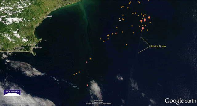
MODIS satellite image of Campos Basin, Brazil, showing long plume of smoke emanating from oil production area. Combustion sources identified from nighttime VIIRS satellite data shown by red markers. Image taken December 31, 2013.
The smoke plume appears to emanate from a point about 2.7 miles north-northeast of Petrobras Platform 51, a big semisubmersible rig in the Marlim Sul field. The VIIRS data indicate the presence of a combustion source at the north end of the smoke plume, and estimate it’s temperature is 1800 degrees Kelvin — this is extremely hot, hot enough to soften steel. The plume visibly extends to the south for at least 146 miles.
It’s possible this is just an unusually vigorous gas-flaring event, but we don’t see comparable plumes of smoke from the many other flares detected in the area. We haven’t heard anything but are concerned there may be a fire at a platform or drill rig working at this location.
If you have any news, please let us know by commenting on this post and/or emailing us (info@skytruth.org).


This could also be a vessel fire — but we checked the satellite AIS (Automatic Identification System) data for the area and didn't see any sign of a broadcasting ship in the vicinity. Vessels smaller than 300 tonnes displacement are exempt from using AIS, but most large vessels, including cargo ships and tankers, do.
We are still investigating the details, but since satellites show smoke and heat signatures at a consistent location in the Campos Basin on Dec. 27 and from the 29th through today, these incidents could very well be related. As stated earlier, one possible explanation is aggressive flaring because of the cutbacks to production mentioned in the article.
Is it the fire reported on 12/27 on platform P20?
http://www.reuters.com/article/2013/12/27/petrobras-platform-fire-idUSL2N0K613M20131227
Based on the platform data we have (from 2012), P20 is located about 17.4 miles to the north of the source of the smoke plume. So I don't think these are directly related.
This fire on P20 is true.
"Petrobras informs that production of the P-20 platform, located in granting the Marlim field in the Campos Basin, remains stopped after fire occurred in the late afternoon of Thursday (26/12)."
Source: http://vitorianews.com.br/noticiario/noticia/2013/12/incendio-interrompe-producao-da-plataforma-p-20-na-bacia-de-campos-6kZAg2PmH6UIZOfbBszse.html
Media accounts have identified a fire at P20 or at P35, but neither of those is close to the location of the smoke plume on December 31. And if the fire was extinguished on December 26, we would not expect to see such a large plume on December 31. This mystery is not yet solved.