Bad News for Pollution Monitoring – US Needs a Radar Satellite, Stat!
It appears that we’ve lost one of the most important tools in the field of Earth observation: on April 8, the Envisat satellite stopped communicating with its handlers at the European Space Agency. While this is not happy news, the satellite was a real workhorse well beyond its expected lifespan and was an outstanding success for ESA’s program.
We routinely used radar satellite images collected by Envisat’s ASAR sensor, and low-resolution optical-infrared images from the MERIS instrument, to monitor places around the world for oil pollution related to offshore oil and gas development and shipping. As a tool for tracking vessels throughout the ocean, ASAR was also useful for monitoring fishing.
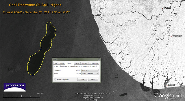
Here’s a recent example of our work using ASAR, illustrating and measuring Shell’s major oil spill off the coast of Nigeria last December:

Envisat ASAR image capturing Shell oil spill off Nigeria in December 2011. Image courtesy European Space Agency.
There are other options, none quite as good as ASAR for its combination of coverage, capability and availability, and cost. We’ve used radar satellite images from the TerraSAR-X and Cosmo-SkyMed systems, operated by Germany and Italy, for various oil spills including the BP / Deepwater Horizon disaster in 2010 and the Montara blowout and spill off Australia in 2009. Canada’s commercially operated Radarsat is an excellent system comparable to Envisat’s ASAR, although the data cost makes large-area monitoring a very expensive endeavor. And the European Space Agency is planning to launch Sentinel as a followup to the Envisat program, although that launch is not expected for at least a year.
Which brings me to my #1 complaint about the US space program: why doesn’t the US have its own civilian radar imaging system? We once led the world in this technology with the incredible success of SeaSAT way, way back in the day (remember 1978? we WERE the champions!) and we haven’t launched a civilian radar satellite since.
This is a big mistake. Radar imaging satellites are the #1 tool for conducting cost-effective, routine monitoring of large, remote ocean areas to detect and track vessels and pollution. Other countries are using imagery hand-in-hand with their enforcement agencies to clamp down on pollution, illegal fishing activity and smuggling. The U.S. has vast, far-flung ocean spaces to manage, amounting to half of our total territory. Maritime monitoring has evolved into a national security issue far too important for the U.S. to continue being dependent on foreign- and commercial-operated radar satellites. Congress, let’s get on the ball and fix this glaring security gap.

