And the under-reporting continues…
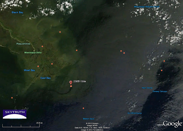
On 4/20, SkyTruth Alerts received a report from the NRC that was apparently submitted by Taylor Energy. They reported a spill of 4.72 gallons, with a slick 400 feet by 6.2 miles. Our SkyTruth calculations assuming a minimum average thickness of 1/1000th of a millimeter suggest that this slick held closer to 321 gallons. And the MODIS satellite image for that day shows a slick coming from that location that measured not 6.2 miles long but just over 19 miles long:
On 4/25 the SkyTruth Alerts received another report from the NRC apparently submitted by Taylor Energy. This time the reported spill amount was listed as 5.64 gallons, with a slick of 500 feet by 4.8 miles. Our SkyTruth calculations suggest that this slick holds about 311 gallons. And in that MODIS image, the slick appears to be 19.04 miles long:
The report from the 25th was taken at 9:00 a.m. and the MODIS image that shows the slick was taken about 2 hours later. We don’t think it’s likely that the slick could have grown from 4.8 miles long to over 19 miles long between the time the report was called in and the time the image was taken. It’s possible that under the right conditions satellite imagery is a better tool for detecting and measuring the full extent of a slick than direct observation from aircraft or on the water.


Is there any way to monitor the methane emissions at Total's Elgin gas well in the North Sea? All we're hearing for weeks now is Total's figures. They claim the leak is "down" to about 2,000,000 cubic feet of methane being released a day. But a month on, the thing is still spewing — and since there's no good black, gooey photo ops the major news outlets have dropped almost all coverage. It needs to be seen & shown.
Harry – an excellent question that I think you asked us already (see http://blog.skytruth.org/2012/04/gas-well-blowout-in-north-sea-small.html?showComment=1333989840904#c1047073086321079822). The only orbiting systems I'm aware of that we have launched so far to measure methane have been passive, indirectly detecting methane by measuring the absorption of reflected sunlight at specific wavelengths. It's hard to tell where in the atmosphere the methane is – is it near the ground, or at a very high altitude? – and the signal to noise ratio is low, so the sensor has to measure over a broad area (i.e., low spatial resolution) to collect useful data. This is OK for measuring country-wide methane emissions but not detailed enough to see a point source, even a big point source like the Elgin blowout.
The Germans and French are collaborating on a satellite mission called MERLIN that will operate an active, LiDAR (laser) system to measure methane directly, but that sensor won't be launched until 2014 (http://www.spacedaily.com/reports/World_Map_Of_Methane_Concentrations_999.html). Hopefully the Elgin leak will be killed by then! But as long as we're drilling, there will be other leaks to study.
I'm curious if Harry has a real point — I wonder if, once the summer heat hits that black ocean, if the methane will cause an appreciable feedback? And if that part of the sea warms up more than usual, what will be the result? Storms? It will be interesting to see what happens.
ljgeoff – this methane is being released directly into the air from the platform, so it's blowing away from the leak site and mixing with the atmosphere. Will this result in any measurable local effect on climate in the North Sea or the Arctic? I'd love to have a few atmospheric scientists weigh in on this question. For me the bigger question is how the cumulative impact of occasional major incidents like this one — plus the ongoing fugitive emissions of methane from the exploration, production, processing and transport of natural gas — is affecting global atmospheric chemistry and global climate.