Tar Sands Mining: Well, Canada is sorta big right?
It is one thing to say that the Athabasca tar sands mining project is a behemoth- quite another to actually see it. Here at SkyTruth we have always recognized how powerful a story real-world images can tell.
Check out our newest addition of satellite “truthing” – A quick animation of the growing Athabasca tar sands mining “footprint” and future extent.
Big tip o’ the hat to Global Forest Watch Canada for providing the mining data.
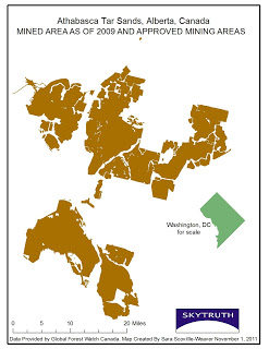
We have placed the boundary of Washington, DC on top of one of the open-pit mine locations to give viewers a sense of just how vast this whole operation is. Have any of you ambitious tourists ever attempted to walk the length of the National Mall from the U.S. Capital to the Lincoln Memorial?
It’s farther than it looks (as my feet will attest) – about 1.9 miles to be exact. Now imagine that instead of strolling along green lawn you are bobbing in the middle of a 4 mile wide industry tailings pond, full of sand and a host of known toxins. This distance, indeed the entire area of the District, is minuscule in comparison to the Athabasca extent.

Future mining extent and 2009 mined extent
And don’t forget the future, already approved extent of mining not yet begun. Or the much larger area of surrounding land used for in-situ, or on-site, extraction operations not shown in this animation; here’s a pic showing the landscape impact of in-situ development.
Jeepers.
As citizens and policy makers alike gear up for the largest protest yet against the Keystone XL pipeline happening this Sunday, November 6 at the White House, it is important to remember that no event occurs in a vacuum. Approval of this pipeline will open up new markets for tar sands oil in the US, Mexico, Central and South America and Europe – and put this already vast mining and extraction operation on steroids.

