
BP / Gulf Oil Spill – Cumulative Oil Slick Footprints
Thought it might be interesting to take a look at the work done by others on the BP / Deepwater Horizon oil spill in the Gulf of Mexico, and compare SkyTruth’s total cumulative oil slick analysis to theirs. Here is our analysis, based on visual assessment of dozens of satellite images acquired from late April through mid July:
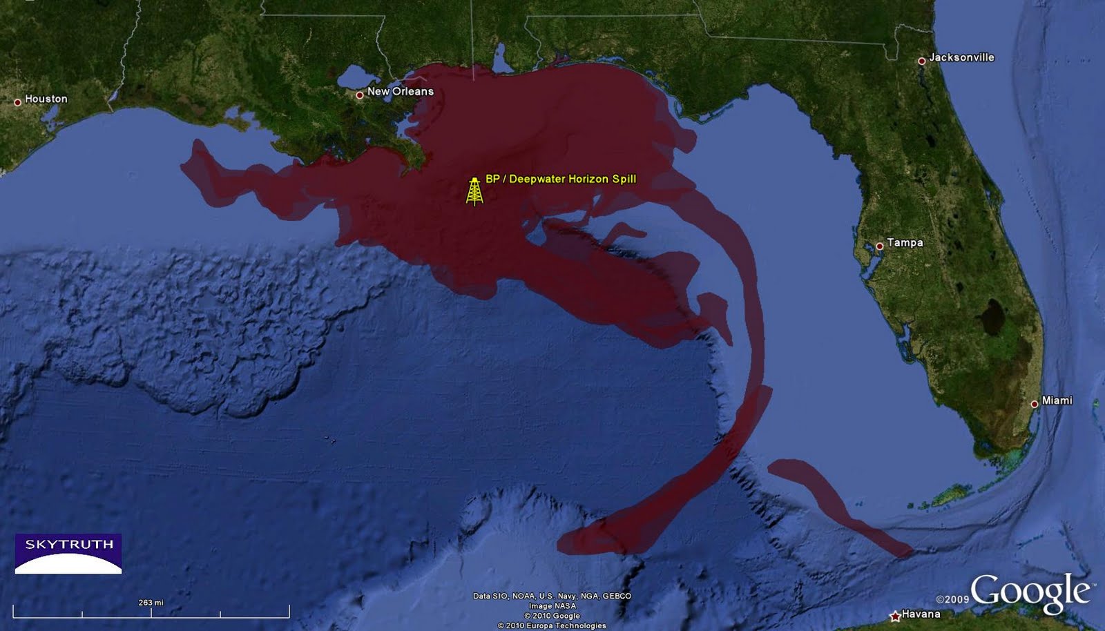
Cumulative BP / Deepwater Horizon oil slick footprint (red). Analysis by SkyTruth.
And here’s the official analysis done by NOAA, using many of the same satellite images, but also including many full-resolution radar satellite images that the public did not have access to (the US doesn’t operate any civilian radar satellites, so the radar images were purchased from foreign companies that don’t allow NOAA to “redistribute” the images):
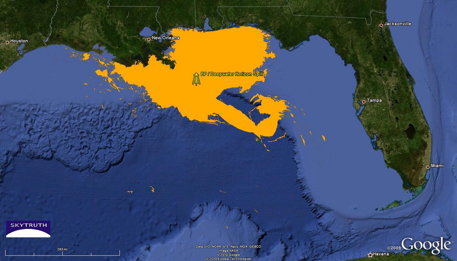
Cumulative BP / Deepwater Horizon oil slick footprint (orange). Analysis by NOAA, compiled by SkyTruth.
The folks at ROFFS (Roffer’s Ocean Forecasting Service) also analyzed satellite images and other oceanographic data throughout the duration of the spill, and just released their preliminary cumulative analysis. We don’t have it digitally yet, but we’ve clipped their graphic to roughly show the same area in our two Google Earth-based maps above:
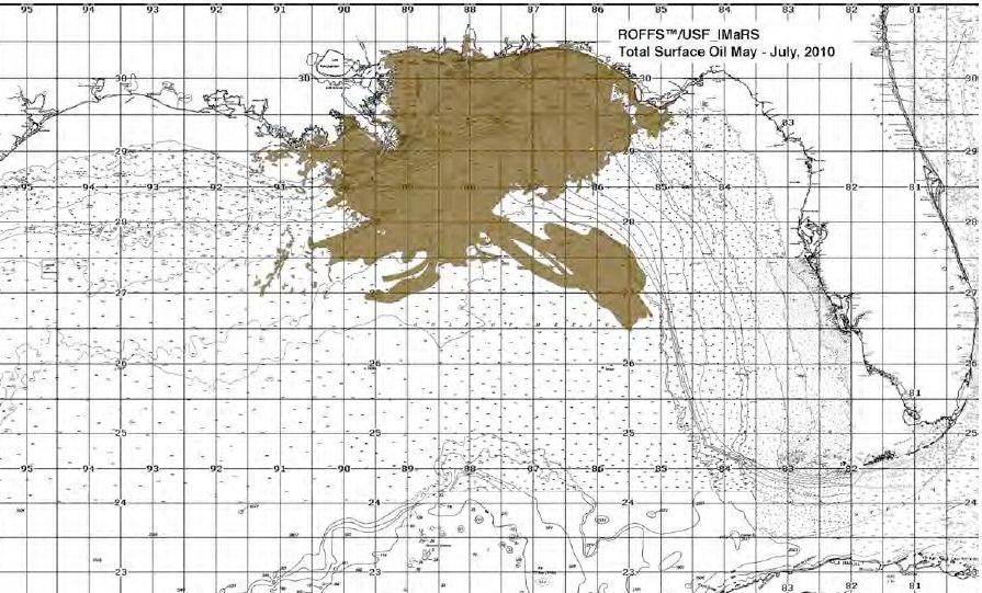
Cumulative BP / Deepwater Horizon oil slick footprint (brown). Analysis by ROFFS.
Overall, the NOAA and ROFFS analyses are in general agreement. The total NOAA oil-slick footprint covers 46,299 square miles (119,915 km2). SkyTruth’s analysis is similar except for our inclusion of possible oil sheen entrained in the Loop Current and entering Florida Straits late in May, before a large clockwise eddy (Eddy Franklin) got organized and effectively kept the slick bottled up the the northern Gulf for the remainder of the summer. The total oil-slick footprint in our analysis is 68,000 square miles (176,119 km2).

If I’m interpreting all those graphics correctly, everyone seems to be in basic agreement that oil did not flow into the Atlantic. Any scientific assessment includes a confidence metric. But just be casual. Are you very sure, somewhat sure or not sure at all that no oil got into the Atlantic? Are the reports of oil on Florida’s east coast mistakes? Are the fish kills up north unrelated to the Gulf? Are the reports of a disruption to the ‘Atlantic Conveyor’ and a change to the Gulf Stream just bogus fear mongering to scare the internet gullibles?
Mark – these analyses all share the same weakness: no ability to directly assess how much oil was beneath the surface of the water, and where that oil was moving. We clearly observed part of the surface oil slick being entrained in the Loop Current in late May. I think it is possible that some of that oil entered Florida Straits before Eddy Franklin shut off the circulation, but no water-sampling or direct observations confirm that, so it would most likely have been be very low concentrations of dispersed oil.
I don't doubt the reports of oil off Florida's east coast but it's important to note that oil sightings along our coasts, and the occasional tar ball on the beach, are not uncommon. Most of this is probably from shipping, including illegal disharge of oily bilge from passing vessels. I've seen that on satellite images too (for example, http://bit.ly/bApbyN). Just another reason why we need routine satellite monitoring to detect and deter polluters.
Fish kills from other causes having nothing to do with oil spills – red tides, for example – are also not uncommon.
There sure were a lot of doomsday hypotheses thrown around this summer! Entertaining, but also harmful in that they made the actual impacts of this spill – environmental, social and economic – seem insignifcant in comparison, allowing lots of folks, including some in the media, to claim "hey, it wasn't nearly as bad as they said it could be."