BP / Gulf Spill – NOAA Forecasts Long-Term Threat To Coasts
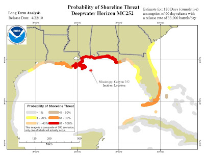
NOAA has just released the results of modeling to analyze the long term threat posed by the ongoing oil spill to coastlines throughout the Gulf, Florida Keys, and East coast shorelines:

NOAA forecast showing likelihood of coastline being threatened by oil over the long term by BP spill
Their model shows the probability that oil will approach within 20 miles of the shoreline. It assumes the net daily spill rate is 1.4 million gallons (33,000 barrels) per day for 90 days beginning April 22, when the Deepwater Horizon rig sank and the fire was extinguished. We’re at Day 76 right now, so this assumes a relief well plugs the leak within the next 2 weeks. They are steadily closing in on the target depth of about 13,000′ below the seafloor, so we’re hopeful BP will succeed ahead of their stated mid-August goal.
The model is based on historical wind and ocean current information, and accounts for the natural breakdown of oil at sea. It doesn’t account for the movement and ultimate fate of oil beneath the water’s surface, because we just don’t know enough about that yet. Read all about the model and the assumptions and data used to run it. You can also see other maps, graphics, animations and movies showing the model results for individual scenarios.


