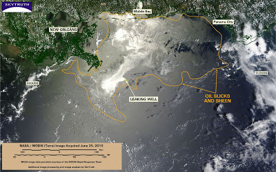
BP / Gulf Oil Spill – Satellite Images Show Oil Impact From Gulfport to Destin
MODIS satellite images on June 25 and June 26 show oil slicks and sheen affecting beaches from Gulfport, Mississippi to Destin, Florida.
Oil slick and sheen cover 24,453 square miles on the June 25 image. Slicks appear to impacting beaches from Gulfport, Mississippi to Pensacola, Florida. Freshly upwelling oil is apparent at the site of the leaking Macondo well, and is moving west in the immediate vicinity of the well:
On June 26, a MODIS/Aqua satellite image shows oil slick and sheen covering 23,049 square miles, threatening beaches from Gulfport and Biloxi to Destin, Florida. To the west, the slick extends to Port Fourchon, Louisiana. Emerging oil is continuing to move west from the well site:


