Atlantic Drilling – New Jersey Oil Spillustration
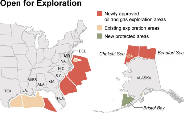
A lot of folks were surprised by the Obama administration’s recently announced plan to expand oil and gas drilling in US waters to much of the Atlantic coast and into the Chukchi and Beaufort seas off Alaska. Alaska’s Bristol Bay, home to a wild-salmon fishing industry that rakes in some $300-400 million every year, will be put off-limits to drilling until 2017.
Under this plan, drilling will be allowed off the Eastern Seaboard from Florida to Delaware:
Map source: New York Times
SkyTruth thought it would be interesting to illustrate what could happen if a drill rig off Delaware had a blowout and spill comparable to what we saw unfold off Australia last year. So we took the cumulative oil slick “footprint” – all of the oil slicks we observed on NASA satellite images throughout the ten-week duration of the Australia spill – and transposed it onto the Atlantic coast, assuming the source of the spill was a well 60 miles off the Delaware shore. The entire coast of New Jersey, from Cape May to Sandy Hook, would be impacted:
Hypothetical illustration showing 2009 Australia oil spill superimposed on Atlantic coast.
This image was used by New Jersey Senator Lautenberg in a meeting yesterday with Senators Kerry and Lieberman, who support more offshore drilling if it helps gain the votes they need to pass a climate bill. Lautenberg, and his colleague Senator Menendez, aren’t big fans of that plan.
We want to stress that our illustration is hypothetical. It’s not based on a numerical model of how oil would likely move and disperse if a well off Delaware really did have a major problem; that’s a function of wind, tide, current, the properties of the oil, the rate and quantity of spillage, and of course the effectiveness of our efforts to contain the oil in such an incident. But this illustration is based on actual observations of a real event, the Montara / West Atlas blowout and spill that we tracked in the Timor Sea off Australia last year.

