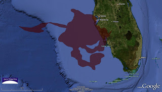
Timor Sea Drilling Spill – Superimposed on Florida Coast
Given the big Hands Across the Sand event tomorrow that’s getting so much media attention down in Florida, we thought it would be interesting to take the cumulative Timor Sea oil slick footprint from the Montara / West Atlas blowout and spill last year and superimpose it on the Gulf coast of Florida. This is not a spill simulation; it’s just a map intended to show how large an area of ocean the Australia spill ultimately impacted during the ten-week period after the blowout until the spill was finally stopped:

Cumulative Timor Sea oil spill footprint superimposed on Florida’s Gulf coast.
This is based on SkyTruth’s analysis of MODIS satellite images provided by NASA throughout the event, from August 21 to November 1. Read all about it in this blog; see our large collection of images and maps; and follow us on Twitter to stay tuned in on all our latest work.
And if you like what we do, and want us to keep at it, please make a donation – SkyTruth is a 501(c)(3) non-profit organization registered with the IRS, and your donation is fully tax-deductible.

