Mountaintop Removal Mining, Part 2: Mountains at Risk
SkyTruth, in partnership with Appalachian Voices, documented the impact of mountaintop removal coal mining (MTR) over a 59-county area in Kentucky, West Virginia, Tennessee and Virginia by mapping the extent of mountaintop removal mining over a 30 year period using satellite imagery. The historical record shows a 250% increase in MTR occurring over the last two decades, from 77,000 acres in 1985 to over 272,000 acres in 2005. The size of the individual mines also ballooned, with some now covering 15 square miles. Over 2,700 mountain ridges were destroyed by mining.
While this impacts an enormous area, how many more ridges and mountaintops are vulnerable to this destructive practice?
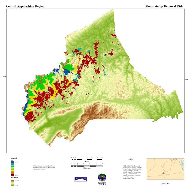
In order to create a risk map, the variables that correlate with MTR must be identified. Our Chief Scientist, Dr. David Campagna, performed a preliminary investigation to determine the drivers of mining occurrence in Wise County, Virginia. Variables such as coal thickness, overburden, land use type, roads, and hydrography were investigated along with our previous analysis of historical to recent mining activity.
Results indicate that two geologic criteria – coal thickness and overburden – best correlate with mining. Using these two variables, we generated a mining risk map for the county based on analysis of the main coal deposit in the area, the Pond Creek seam (see above). Knowing which ridges are at risk of being mined is the key to developing proactive strategies to limit further destruction, and predicting downstream impacts should mining occur.


