Timor Sea Drilling Spill – 4th Relief Attempt Fails
The fourth attempt to kill the out-of-control well on the Montara platform was scrubbed due to equipment problems. The well has now been leaking oil, gas and condensate for 70 days. And the operator, PTTEP, is now saying the well may not be plugged for “several more weeks.” Indonesia officially confirmed that oil has reached their territorial waters, something we documented in satellite imagery back on September 3.
World Wildlife Fund just released a report on their research cruise to the spill-affected area, where they observed slicks and impacted wildlife. See their photos and video for an up-close look, and get the full report here. (Photo #4 shows researchers studying a SkyTruth image of this spill.) The Australian government has also released a report on the research and wildlife surveys they’ve conducted so far in the area.

Common Noddy recovered from the Montara oil spill by researchers working for the Australian government. Photo taken from their report.
Meanwhile, a second leaking well has been reported in another offshore field about 50km northwest of Montara. This is being described by the company as a minor gas leak but it’s been ongoing for some time with no immediate prospect for repair. Fugitive methane emissions such as this from oil and gas facilities could be a major source of greenhouse gases in the atmosphere.
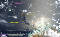
Here’s a visual of those emissions: we processed a MODIS satellite image of the Montara area that was taken on October 27. The well is still actively spewing oil, but the sunglint conditions on this image are not favorable so the slicks aren’t visible. But a pale plume is emanating from the platform location and spreading out as it blows toward the Australian coast to the southeast. This is probably an aerial plume of hydrocarbon smog caused by the natural gas and vaporized natural gas condensate that are also blowing out of the damaged well. Usually those airborne emissions are invisible, but atmospheric conditions must have been right to form a visible smog:
 See all of our images here. And if you like what we do here at SkyTruth, please support our work!