Timor Sea Drilling Spill – New Air Photos
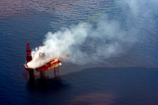
SkyTruth just got new aerial photos of the Montara platform, taken on an overflight by Environs Kimberley on September 12. The platform is still spewing crude oil into the Timor Sea and a potentially explosive fog of natural gas and gas condensate into the air. The West Triton rig is visible in one of the pics; it’s begun to drill a relief well that will attempt to intercept the damaged well 8,500 feet below the seafloor, a process that will take 3-4 weeks at best.

Montara platform and West Atlas drill rig, September 12, 2009. Photo courtesy of Environs Kimberley.
Also visible: extensive oil slicks and sheen still covering the sea in the vicinity of the platform, in calm seas. This spill has been uncontrolled now for almost a full month.
Click here to go to our growing gallery of aerial photos, maps and satellite images.


Wow, crazy. Amazing the amount of things going on that people just don't know about. I would've thought they would have some sort of on/off switch, so if it's broken, they could just turn it off. But I guess tapping into such a large natural reservoir makes that unfeasible.
Thank you so much for posting the information that you do. The media in Australia has gone quite on the spill for the last week and your site helps me to keep the issue in their face.
This is only the beginning of LNG production on the Kimberley coast,one of the last wilderness in the world. So, again thankyou for your support. Redhanded http://handsoffcountry@blogspot.com for up to date information about our struggle to safe this country. Hands Off Country and Standing up for the Planet.